Project Sites
Nelson Island
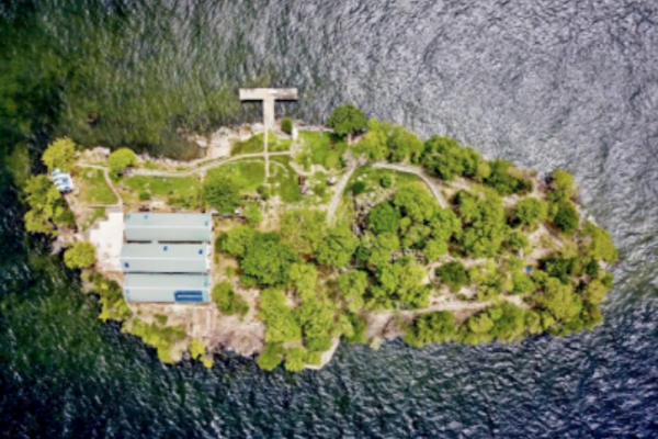
Nelson Island is one of a cluster of small islands called the Five Islands. The Five Islands are an archipelago of six islets located in the Gulf of Paria approximately 2.5 kilometres due south of Chaguaramas and due east of the prison island of Carrera. Nelson has an area of 1.7 hectares. Nelson Island has clashed with several periods of Trinidad history.
Firstly, the island was supposedly used as a trading post by the First Peoples before the 15th century trans-Atlantic contact period. In the Spanish colonial period (1592-1979) the island was used as a way station between Trinidad and other Spanish possessions within mainland South America. During the pre-20th century British colonial period, Nelson Island functioned as a quarantine station and a convalescent station for newly arrived Indian Immigrants. In World War two, the island served as a naval station for the United States Navy, an internment camp for enemy alien internees and a detention centre for labour leader Tubal Uriah Buzz Butler. The island was again used as a detention centre 1970 to house 50 individuals associated with Trinidad’s Black Power Revolution.
Nelson Island is a limestone Island, low and arid, this formation was raised by geomorphic action, considerably metamorphosed, and eroded over millions of years. Considerably weathered with only a thin layer of clay soil. Rainfall is typical of the general area with an estimated 150mm per year but there is no natural standing or running water. It is exposed to sustained winds from the east and south east for much of the year. Nelson Islands’ topography consists of a relatively flat and weather western portion, and an eastern steeper portion which contains a jagged and notched outcrop of limestone.
Nelson Island is Listed as a Grade B – an area, site or place of natural beauty or repose that would be despoiled if it were to be altered by the introduction or removal of any flora, fauna or work of man. The site has been given protection under the provisions of the National Trust of Trinidad and Tobago Act, Chap 40:53, and is referred to as a ‘Listed Property of Interest’. In other words, this refers to designating and safeguarding the ‘listed national heritage site’ as it is commonly called.
View additional information and photos at The National Trust of Trinidad and Tobago website.
St. Vincent Jetty Lighthouse
The Port of Spain Harbour was initially a strip of land that grew as a result of reclamations under Governor Woodford. Under his directive, land reclamation projects became a priority in Port of Spain resulting in the expansion of the port and waterfront. During the latter 1800s land was reclaimed in order to extend Queen’s Wharf starting from the south of Marine Square (now Independence Square) continuing to South Quay and further on.
Nearer the end of the 19th century, land was also reclaimed from St. Vincent Street, as well as the stretch continuing eastwards toward the Dry River resulting in South Quay and the St. Vincent Wharf. Because of these reclamations – specifically the Queen’s Wharf- the port created an environment for smoother economic transactions between merchants allowing for increased business, which eventually required the construction of the Lighthouse in 1842.
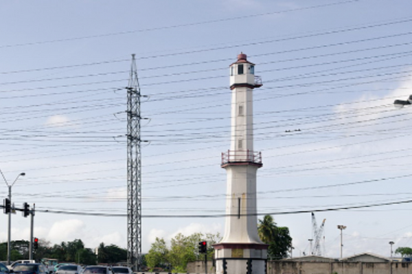
Originally built in 1842 by Governor Colonel Sir Henry Mcleod, the lighthouse was built at the end of the St. Vincent Jetty to assist sea traffic for ships entering and leaving Port of Spain’s Harbour. The Lighthouse was initially situated at the end of a 35 metre long jetty leading from the sea front. This was prior to the second and third phases of the reclamation of Port of Spain’s waterfront in 1845 and at the end of the nineteenth century. The execution of the deep-water wharf project in the 1930’s, furthered the removal of the lighthouse from the shore as it was now marooned inland.
It is in the centre of Wrightson Road, opposite Broadway and across from the Trinidad Government and Railway Building. It is a brick-and-mortar hexagonal structure, 64 feet in height. Possesses a gallery midway on the length of the structure and a lantern room at the peak. The Lighthouse has a gate facing west located at the base and three vertical ventilation holes near the basin. The structure leans at a 5 degree angle in a westerly direction due to renovation and restoration work. It is located in the epicentre of the capital in the middle of a heavily trafficked, flood prone intersection.
The Lighthouse is a grade 2 Property – in which material change may be permitted provided that similarity is maintained in all respects as the original composition, shape and form. The site has been given protection under the provisions of the National Trust of Trinidad and Tobago Act, Chap 40:53, and is referred to as a ‘Listed Property of Interest’.
View additional information and photos at The National Trust of Trinidad and Tobago website.
PTSC/Old Railway Station
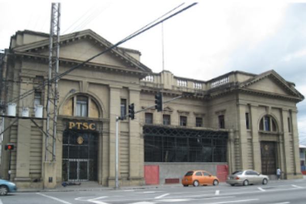
The Old Railway Station building otherwise known as “City Gate” is the second railway station building to exist at its current location replacing the old wooden structure before it. The building, formerly the Trinidad Government Railway (TGR) building, was the metropolitan hub for the railway lines which connected Port of Spain to various parts of the country. It was designed by German architect, David Hahn, and was completed in 1924.
The TGR administration building, can be described as typical of the neoclassical Colonial designs in Trinidad. The building is architecturally significant for its splendour, built at a time when the Colonial Government controlled the public transport system which had been so important in the development of the island. The coming of the railway served to democratise travel for all levels of society. Sadly, the new headquarters in 1924, instead of imposing continued dominance, marked the beginning of a long period of decline for the railway system in Trinidad, along with the importance and influence it once exercised across the island. Once considered the pride of the Colonial Government the TGR was officially closed on the 31st December 1968. Today, it is managed by and houses the headquarters of TGR’s successor, The Public Transport Service Corporation (PTSC) and it is used as the Port of Spain Bus Terminal.
The station is located between South Quay and Wrightson Road/Beetham Highway and Broadway, Port of Spain. Located in a heavily trafficked area in the heart of Port of Spain and serving as a transport hub for the public, the Old Railway Station is victim to extensive damage from heavy sewer floods resulting from constant pollution as well as major land reclamation projects which altered the coastline of the Port of Spain Harbour which occurred during the 19th century.
View additional information and photos at The National Trust of Trinidad and Tobago website.
Fort San Andres
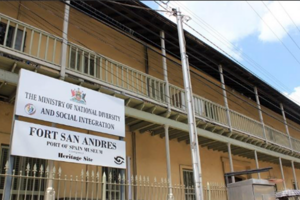
Fort San Andres is the last surviving fortification from the period of the Spanish occupation of Trinidad, which came to an end in 1797 with the capture of the island by the British. As early as 1733, a fortification called Fort San Andres was planned to replace a redoubt of fascines and earth, which was the only defense to Port of Spain. This was not completed until 1787. The redoubt was located where RBTT now stands on Independence Square.
reclaimed constructed as a mole linked to the mainland by a wooden bridge. In 1845, the Port of Spain Town council approved the filling of the Port of Spain waterfront to the Northern side of Fort San Andres. Late in the nineteenth century the shoreline was filled again to its present line, completely land-locking the fort. Fort San Andres fell into disuse and later a structure was built on the old fort to house the Harbour Master and various other government offices, including the Police Service Traffic Branch. In 1995, the building was restored and converted to a Museum of the City of Port of Spain. Several of the original cannons survived and the foundations bear the date 1785. Fort San Andres is located in South Quay and is currently not in use. South Quay is a highly trafficked and flood prone area.
View additional information and photos at The National Trust of Trinidad and Tobago website.
© Resilient Heritage | Trinidad + Tobago. All rights reserved. A Project of the National Trust of Trinidad & Tobago. Funded by


